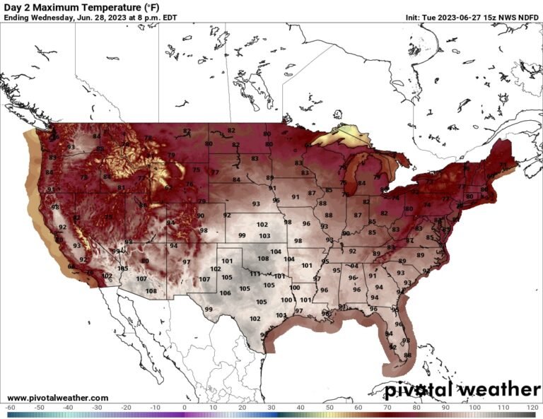
Heat advisories from northern Florida to southern New Mexico, and extreme heat warnings have been issued for much of Texas and parts of New Mexico and Arizona and along the Gulf Coast of Louisiana, Mississippi and Alabama. New Orleans is included in the zone with the greatest risk of heat, with actual air temperatures around 100 degrees and humidity that will push the heat indices to 115 degrees.
Extreme heat watches, meanwhile, are in place for the lower Mississippi Valley and include Memphis and Nashville; Huntsville and Birmingham, Ala.; Jackson, Miss., Little Rock; and Poplar Bluff, Mo.
“Extreme heat and humidity can greatly increase the potential for heat-related illnesses,” warns the National Weather Service, “especially for those who work or participate in outdoor activities.”
The heat will ease early next week for parts of the Southeast and Mid-South, but there’s no immediate end in sight for Texas, where blistering and brutal conditions look set to continue.
Fueling the heat is a stagnant ridge of high pressure parked over Texas. That “heat dome” carries warm, sinking air while diverting storm systems around it to the north. Uninterrupted sunshine helped the temperature rise by 8 degrees to 18 degrees above average.
What sets this hot dome apart is not just its size, however. Stubbornness and long life also play a major role in its anomalous effects. The city of Del Rio, Tex., hit 115 degrees June 21, for example, and could reach its 10th consecutive day of tying or breaking the record high.
Even more noteworthy are the city’s overnight lows, which have not dipped below 80 degrees since the morning of June 15. Del Rio’s average low during mid-to-late June is 74 degrees, but increased humidity – such as contributes to dangerous daytime heat indices – produces warm overnight lows. That’s especially problematic, because high night temperatures prevent the body from achieving the necessary cooling at night.
Soupy humidity will continue to flow north from the Gulf of Mexico. Dallas recorded an 80-degree dew point on June 15, tying its record; this mark has only been reached five times since 1947. That oppressive sultriness will overlap with warmth until the overarching weather pattern finally breaks over the weekend.
The heat is about to spread to the Mississippi Valley. So, although Texas will experience continuous highs between 100 degrees for areas including Houston, San Antonio and Austin and low 100s in Dallas and as high as 110 degrees in San Angelo, the worst of the no will soon spread to the north and east.
Oklahoma City will experience a brief heat wave. Highs will likely touch 105 degrees Tuesday and return to the low 100s Wednesday. That would tie the record of 105 set in 1980.
New Orleans may not break 100 degrees for actual air temperature, but tropical rainforest-like dew points in the upper 70s to about 80 mean that every cubic meter of air contains about 1.5 tablespoons. which is moist. That prevents sweat from evaporating from the human body, which inhibits one’s ability to cool oneself and worsens heatstroke. Heat indices will range from 113 degrees to 117 degrees through the weekend.
Jackson, Miss., will face highs in the upper 90s to 100 degrees, with these heat levels likely to continue through Friday. For Memphis, triple-digit highs — and heat indices above 110 degrees — are likely Thursday, Friday and Saturday. And Nashville could also hit 100 every day in the same window, with equally dangerous heat indices.
The heat should finally begin to dissipate from Sunday as the parent heat dome flattens.
